INFO
How Big is Gaza?
Due to the war, the information presented is subject to rapid change. All figures have been gathered from reputable sources, but many are ranges or estimations.
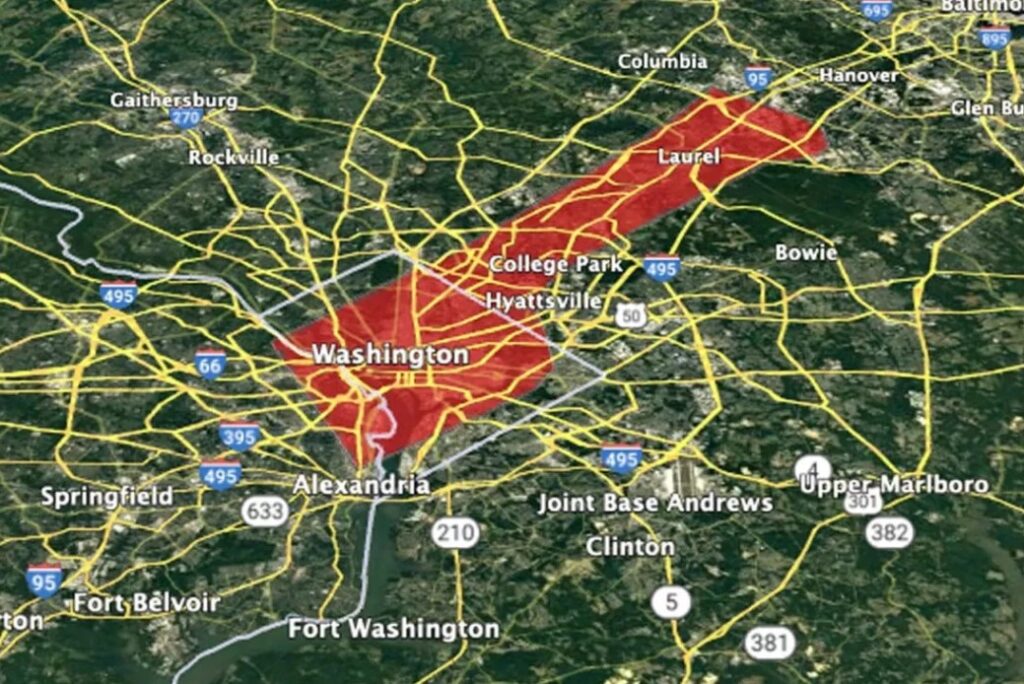
The whole of Gaza (aka the Gaza Strip) is about twice the size of Washington, D.C. and three times the population. Bordering the Mediterranean Sea, Egypt and Israel, Gaza is a 25-mile long stretch of coastal land (141 square miles, 365 square kilometers).
Gaza’s coastline is 40 kilometers (24 miles) long.
The Gaza Strip is geographically about the size of Philadelphia, Detroit or the country of Grenada.
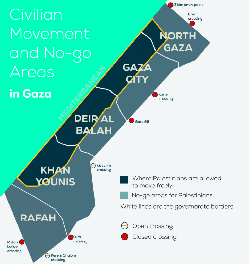
As Israel continues to invade the Gaza Strip, the land has become increasingly inaccessible to residents. While the territory itself has not shrunk, Israel now controls 50% of Gaza, pushing Palestinians onto less and less land. The growth of the military buffer zone along Gaza’s border, as well as the implementation of a new corridor across the south, significantly restricts Palestinian movement.
How big is Gaza’s population?
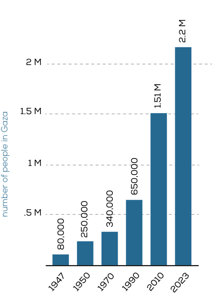
The Gaza Strip has almost exactly the same land area as Las Vegas but more than three times the population. There are approximately 2.1 million residents of the small territory.
Before the war, Gaza’s largest city, Gaza City, had a higher population density than any major U.S. city, including New York, with more than 650,000 people living within its 18 square miles. The population of the city, after two years of war, is as of yet unknown, but it is likely to have an even higher density due to the forced movement of the population into smaller areas.
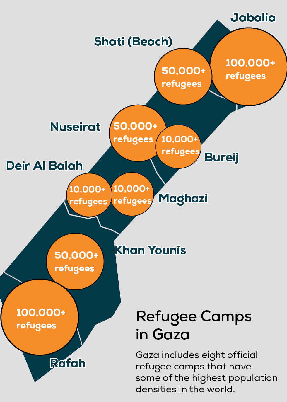
About 80% of Gaza’s population were refugees before the war began. They lived in eight refugee camps – Beach camp, Bureij camp, Deir Al Balah camp, Jabalia camp, Khan Younis camp, Maghazi camp, Nuseirat camp and Rafah camp. The war has since displaced some 90% of Gaza's residents, making most of them refugees again and again.
Jabalia Refugee Camp, once Gaza’s most densely populated area, has been decimated by successive Israeli military offensives since October 2023. The camp, home to 100,000+ registered refugees, has experienced widespread destruction, with reports indicating that the majority of its buildings have been reduced to rubble.


How big is Gaza compared to the West Bank?
The West Bank is much bigger than Gaza, spanning about 2,260 square miles compared to Gaza’s 141 square miles. The population of the West Bank is 3.25 million, only about 1 million people more than in Gaza, meaning the population density is significantly lower.
What is the distance between Gaza and the West Bank?
Palestine is made up of the West Bank, East Jerusalem and Gaza. The West Bank and Jerusalem are connected, though checkpoints make movement challenging. Gaza, however, is separated from the rest of Palestine. At their closest points, Gaza and the West Bank (Hebron) are 50 kilometers (30 miles) apart, but Palestinians need Israeli permission to pass through Israel.
What is Gaza's access to the outside world?
Before the war began in October 2023, the 12-kilometer (7.5 mile) Rafah border with Egypt was the only direct border to the external world. Rafah was one of three crossings for Gaza residents. The other two crossings, Erez in the north and Kerem Shalom in the south, were under direct Israeli control.
However, in May of 2024, Israel seized the Rafah crossing and implemented a total closure of that border. Gaza is now completely surrounded and blockaded by Israel.
Even before October 2023, Gaza’s residents lived under a blockade that severely restricted movement and the flow of goods. During the war, those restrictions tightened further, alternating between total closure and brief, heavily controlled openings that allowed only limited amounts of food, fuel, medicine, and aid to enter. Now, after a tenuous ceasefire has gone into effect, aid still is not flowing into Gaza in anywhere near the quantities needed. In the meantime, civilians remain trapped in constant uncertainty and deprivation.
For hundreds of years Gaza held importance as a strategic location along the trade routes between empires. It was also a great center for agriculture. Now blockade cuts it off from trading with the world.


